
CAHER VALLEY LOOP
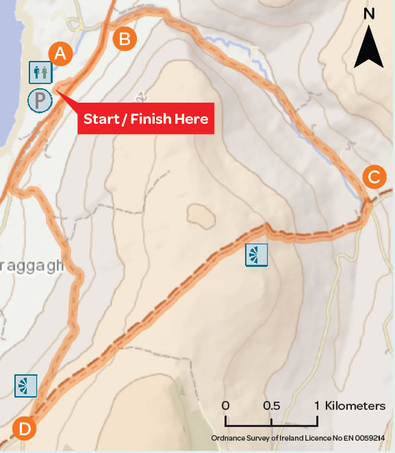
This loop starts and finishes at Fanore Beach, 3km from the village of Fanore a small village situated on the west coast of County Clare. Fanore’s Gaelic meaning “fainne oir” means ring of gold, with reference to its beautiful sandy beach. The Caher Valley runs down to Fanore between Slieve Elva and Gleninagh.
Trailhead: Fanore Beach, County Clare
Services: Fanore (1km), Ballyvaughan (15km)
Distance/Time: 14km / 3.5hrs – 4hrs
Difficulty: Moderate
Terrain: Minor roads and green roadways
To Suit: Average level of fitness
Minimum Gear: Hiking boots, raingear, fluid, snacks and mobile phone
Grid Ref: OS Sheet 51, M142 083
A-B. Starting from the mapboard at Fanore Beach, exit from the car park and turn left following the red arrow. The other coloured arrows are for other walks that start and finish at the car park. Follow the road for approximately 500m to reach a minor road on your right. Take a right turn here.
B-C. Follow this minor road past St. Patrick’s Church (on your right) and with the Caher River running on your left. This river has the distinction of being the only one in the Burren to remain over ground. Continue to follow the red arrows for approx 4km to reach a junction with a roadway on your right at Fermoyle. Following the red arrows, turn right here.
C-D. Follow the red arrows along the roadway for 500m to reach a Y-junction where you veer right onto a grassy track and climb onto the shoulder of Slieve Elva and down to reach a surfaced road at Ballelly.
D-A. Enjoy the descent toward the coastline for 3km and reach a 3-way junction where you turn right onto a sandy roadway which joins the R477 at Fanore National School. Taking care of traffic, walk along the main R477 for 200m and re-enter Fanore Beach car park.
Download Mapcard