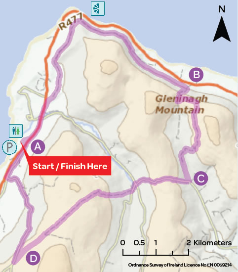

BLACK HEAD LOOP
The Black Head loop crosses through the Gleninagh Pass, and into Feenagh Valley along the shoulder of Cappanwalla Mountain. At a 3-way junction the loop climbs again passing by Caher an Ard Rois, where you travel a short distance on the surfaced road of the Caher Valley, passing through a crossroads. Another green road takes you onto the shoulder of Slieve Elva, and into Ballelly, and back down into Fanore Beach car park.
Trailhead: Fanore Beach, County Clare
Services: Fanore (1km), Ballyvaughan (15km)
Distance/Time: 26km / 5hrs – 6hrs
Difficulty: Hard
Terrain: Green laneways, tracks and mountain paths
To Suit: High level of fitness
Minimum Gear: Hiking boots, raingear, fluid, snacks and mobile phone
Grid Ref.: OS Sheet 51, M142 083
A-B. Starting from the mapboard at Fanore Beach, exit from the car park and turn left following the purple arrow. Follow the road for 1km (passing a crossroads after 500m) to reach a junction with a sandy roadway on your right - turn right here. Follow this roadway uphill for 500m to reach a stone stile where you cross into a field and join the green road which takes you around Black Head. After 5km, the loop leaves the green road, turns right and uphill to join a well-worn path along a stone wall. Follow this path/ wall for over 2km to reach a mountain path at a stone stile and metal gate (on your left). Continue straight on here.
B-C. For the next 1km the mountain path ascends steeply to reach a stone stile at Gleninagh Pass. Cross the stile, turn left, and follow the stone wall on your left for 500m to another stone stile. Follow the waymarkers carefully now as the loop veers right away from the stone wall and swings right to reach a metal gateway and join a sand roadway along the shoulder of Cappanawalla (on your left). After 1.5km the sand roadway descends to join a surfaced roadway in Feenagh Valley. After 1km you reach a 3-way junction where (as the signpost indicates) a number of walking trails meet. You follow the purple arrow and turn right here.
C-D. Now you follow the purple arrows up a steep stony roadway close to Caher an Ard Rois. After crossing the top, the descent takes you down to join the surfaced road of the Caher Valley. Turn right and, almost immediately, left. [Note: You have the option to take a shorter trek back to the trailhead at this point. Follow the surfaced roadway downhill for 4km and turn left when you reach the main R477.] Having turned left, follow the roadway for 500m to reach a junction with a green road where you veer right and climb onto the shoulder of Slieve Elva and down to reach a surfaced road at Ballelly. Turn right (and downhill) here.
D-A. Enjoy the descent toward the coastline for 3km and reach a 3-way junction where you turn right onto a sandy roadway which joins the R477 at Fanore National School. Taking care of traffic, walk along the main R477 for 200m and re-enter Fanore Beach car park.
Download Mapcard